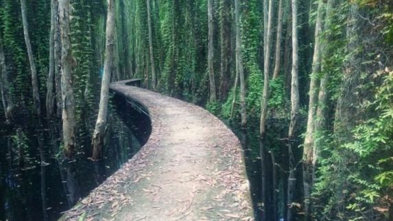
The path through the melaleuca woodland in Tan Lap
A five-kilometer road through a 100-hectare melaleuca forest in Tan Lap floating village in the southern province of Long An demonstrates that Vietnam has many mysterious and beautiful landscapes.
This location is around 100 kilometers from Ho Chi Minh City. This was formerly a natural wetland in Long An province’s Moc Hoa district, near the Vietnam-Cambodia border.
Nature is spectacular, with old melaleuca woods, lotus ponds, water lily lakes, and a variety of birds, fish, and unique amphibian species, resulting in a rich and diversified environment.

The gloomy mystery is heightened by the green hue of melaleuca trees entangled in vines on both sides of the road. The sunlight streaming through the lush greenery adds to the lyrical nature of the pathway.
The rustling sound of footfall on dry leaves echoes in the abandoned forest during the dry season, when fallen melaleuca leaves blanket the path. This is why this roadway has been dubbed the “love lane” of Tan Lap floating village.

Source: MV “Banh Troi Nuoc (Woman)” – Hoang Thuy Linh
Hoang Thuy Linh, the owner of the current hit “See Tinh”, recreated the image of this gorgeous and enchanting route in her popular product “Banh Troi Nuoc (Woman)” in 2016.
Ha Giang province’s brocade road
This colorful path is 1.7 kilometers long and is one of Vietnam’s longest brocade roads.
The roadways are unique in that they were hand-painted by hundreds of villagers who worked together to maintain, clean, and repaint them regularly, rather than by professional artists. On the painting path, there are various themes and pictures distinctive of highland culture.

Binh Thuan province’s drive through the white dunes
Bau Trang is a big natural freshwater lake surrounded by massive dunes that run for 60 kilometers in Binh Thuan province, around 60 kilometers from Phan Thiet. The road Mui Ne – Bau Trang – Phan Ri Cua is widely considered the most beautiful sea road in Vietnam.
Bau Trang road was opened in 2015, is 40 kilometers long and bordered by enormous untamed white dunes and twisting curves enveloping the dunes, providing an outstanding beauty.

Bau Trang is regarded as the “Sub-Saharan desert” in Binh Thuan province, and it is completely covered with white sand when viewed from above. With its beautiful sky and a little green, Bau Trang is an attractive check-in site.
Diep Son Island’s sea-crossing road
Diep Son Island is located in Khanh Hoa province’s Van Phong Bay, which is known for its magnificent straits in the midst of the sea.
The path is around 800 meters long and meanders wonderfully, connecting two turquoise-watered islands in the Diep Son archipelago.

Low tide is the greatest time to explore the mid-sea trail. Its curving road is roughly one meter wide and half a meter deep beneath the pure blue sea. From afar, the fine white sand appears in the center of the water, resembling a lovely bridge heading to Diep Son Island.
The steep road in Gia Lai province
The 1km steep road is part of the route from Gia Lai to Kon Tum province, passing via Pleiku city’s shortcut in Ia Pech commune, Ia Grai district.
On both sides of the road, black cassia trees with yellow flowers bloom. Black and yellow cassava are widely found in the Central Highlands provinces, shading and obstructing the wind near tea and coffee crops.

Because of its remarkable slope, this road has recently attracted a lot of attention from the online photography community. The road’s almost vertical slope, which seems to be a 90-degree angle, is a unique feature.
Its unusual slope piques the curiosity of many tourists. Visitors from all over the world visit Ha Giang to appreciate and photograph these high roads. However, when shooting photographs on this road, you should be cautious and mindful of your personal safety.
@Vietnamnet.vn
