
PERTH, Australia, July 13, 2026 (GLOBE NEWSWIRE) — Alkane Resources Limited (ASX: ALK; TSX: ALK; OTCQX: ALKRY) (‘Alkane’ or ‘the Company’) is pleased to announce the latest exploration results for extension and infill drilling of the Brunswick South deposit, located 400m south of the previously mined Brunswick vein and 200m from planned underground access at its Costerfield Operation in central Victoria, Australia.
Program Summary
- An additional 91 holes targeting the Brunswick South deposit have been drilled since Alkane’s previous update (ASX announcement 15 October 2025 titled ‘Costerfield Resource and Reserve Statement)
- Confidence in grade continuity has been supported by the drilling with the identification of a high antimony and gold grade connection between the recently discovered gold dominant zone at depth and the historical surface workings.
- Drilling is continuing to identify extensions to the deeper gold dominant zone (Kiwi zone) with recent geological interpretation indicating the setting for mineralisation is similar to that of the Youle deposit currently being mined.
- Additionally, parallel veining has been intercepted approximately 200m to the west of Brunswick South with follow-up drilling scheduled to commence shortly.
- An updated Mineral Resource Estimation with initial Ore Reserve is due to be released later in the year.
Brunswick South Assay Highlights
- Brunswick South Vein:
- 50.1g/t gold and 26.2% antimony over 2.17m (ETW 1.08m) in BD468
- 109.9g/t gold and 3.1% antimony over 0.65m (ETW 0.62m) in BD433
- 50.2g/t gold and 33.3% antimony over 0.86m (ETW 0.62m) in BD424
- 39.8g/t gold and 0.7% antimony over 1.3m (ETW 1.15m) in BD408
- 25g/t gold and 0% antimony over 1.7m (ETW 1.64m) in BD513 (Kiwi zone)
- 21.6g/t gold and 6.7% antimony over 1.65m (ETW 0.92m) in BD496
Note. ETW refers to the estimated true width of the veining.
Alkane Managing Director & CEO, Nic Earner, said:
“Focused extension and infill drilling at Brunswick South over the previous year has produced highly encouraging results. This newly defined deposit not only contains pockets of high gold endowment, but critically a significant quantity of antimony. Excitingly Brunswick South can be brought online without extensive access requirements as it is situated 200m from existing development. We are commencing development towards Brunswick South in the current quarter and are looking to establish it as a primary production source for Costerfield.”
Costerfield Gold-Antimony Field
Alkane Resources Ltd 100%
The Costerfield gold-antimony deposit was discovered in 1861, antimony having been already identified in the district as early as 1853 as prospectors attracted to the McIvor (Heathcote) alluvial gold rush began to explore the surrounding hills for the primary deposits. Several lodes along a 3km corridor were rapidly opened up, the bulk of historical production coming from leases at the northern end of the field; the Costerfield (Main), Bombay and Minerva mines. Production from these mines primarily took place in two phases, between 1861-1883 and 1903-1924, and a short-lived attempt at redeveloping the mine occurred between 1933-1939.
Modern mining has been continuous since 2006, when Australian Gold Development commenced underground operations at Augusta, at the southern end of the field. AGD’s Costerfield operation was purchased by Mandalay Resources in 2010, and extraction of the vertically continuous vein system has progressively moved north beneath the Costerfield, Minerva and Bombay group of mines, where Mandalay’s high-grade Youle and Shepherd lodes were discovered.
The Brunswick deposit was discovered in early 1863 (initially called the New Brunswick) and saw limited prospecting through the early life of the field. It was not until the investigations of Mid-East Minerals and the Geological Survey of Victoria between 1966-1971 that the extent of mineralisation at the deposit was intently explored via diamond drilling and the sinking of an exploratory shaft which saw the development of two levels later throughout the 1970s. Australian Gold Development later developed an open cut mine on the Brunswick Reef, extracting oxide gold in 1995-1997. Mandalay Resources mined the Brunswick Reef below the historic workings via underground development in 2018, while developing north from Cuffley to the newly discovered Youle Deposit.
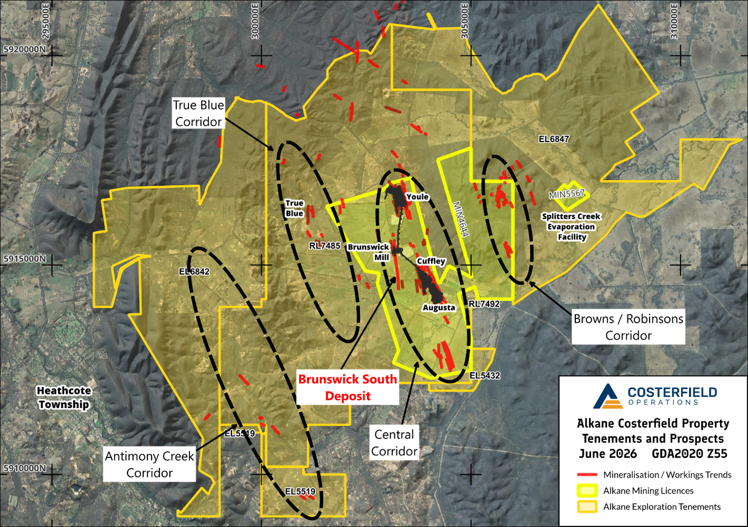
Figure 1. Regional map of the Costerfield Project in GDA2020 grid showing Alkane tenements and the main corridors of mineralisation identified, highlighting the location of the Brunswick South deposit.
A small, near-surface resource delineated by AGD at the time of open-cut mining exists approximately 400m south of the main deposit, which indicated strong structural continuity for the Brunswick deposit outside of the mined area. This Brunswick South deposit remained resistant to significant extension via diamond drilling down-dip, until mid-2025 when a campaign of three diamond holes all intersected high-grade mineralisation over the span of 175m just below the level of the Cuffley-Brunswick access, prompting immediate intensive infill and extension drilling (ASX announcement 15 October 2025 titled ‘Costerfield Resource and Reserve Statement’). The previous high grade intercepts included:
- 76.6 g/t gold over 0.49m (ETW 0.44m) in BD387;
- 265.0 g/t gold and 0.7% antimony over 0.29m (ETW 0.17m) in BD388; and
- 52.3 g/t gold over 1.69m (ETW 1.58m) in BD391
Deposit Geology
The Brunswick Deposit is located at the apex of the Costerfield Dome, between the Augusta and Youle deposits at Costerfield and offset approximately 500m west of the main corridor of mineralisation. The Costerfield Formation host rocks are uniformly siltstones above approximately 900RL (300m below surface), transitioning to thin bedded and fine-grained turbidites below this level. The mineralisation in the north is hosted by a vertical shear that occupies the hinge of the gentle Brunswick Anticline, crossing to an adjacent parasitic syncline in the new southern portion of the deposit. Mineralisation in the vertical, shear hosted part of the deposit tends to be antimony-rich and proportionally deficient in quartz compared to most other worked Costerfield veins, while retaining gold grades comparable to the rest of the field.
North-west trending, steeply dipping faults intersect the Brunswick shear and delineate high-grade shoots within the orebody. This relationship is well understood in the northern part of the deposit where open-cut mining took place and is expected to be important in the south. Bedding-parallel laminated quartz veins and faults are common and influence ore grades at a local scale, the lode structure typically crosses these structures without significant offset or deviation until the Kiwi Fault is reached. The Kiwi Fault is a bedding parallel, laminated quartz fault where seen on the western limb of the Brunswick Anticline, which increases in late, brittle damage and bifurcates into a duplex stack (with the Rooster Fault as its footwall) as it flattens out over the crest of the anticline. In the northern end of the Brunswick deposit where the Brunswick shear intersects the Kiwi Fault where it is almost horizontal, mineralisation splits into several parallel, vertical veins bound between the Kiwi and Rooster fault planes that can achieve high grades albeit with limited ore panel heights. In the new southern area where the Brunswick Shear intersects the fault in a position where it dips moderately westward, mineralisation appears to roll into the fault plane and continue down-dip in a fashion analogous to the Kendal vein system and high-grade Youle Lode in the northern end of the Costerfield Main Corridor. The mineralisation so far encountered proximal to and within the Kiwi Zone differs significantly to the antimony-rich shear seen above, being predominantly free from stibnite and rich in quartz. The gold-rich quartz veining is multiple-generation, containing early brecciated quartz healed by a later quartz matrix.
Below the Rooster Fault, low-tenor mineralisation in the northern part of the deposit continues down dip in a vertical shear of similar character to that above, offset approximately 80m to the west. This area to the south has not been drill tested to date, and the mineralised Kiwi Fault plane is still being explored to determine the extent of mineralisation.
Drilling Results
Since the previous release, 91 extension and infill holes have been completed, totalling 28,421m of diamond drill core. In addition to extending the new high-grade zone, further infill of the existing historic resource was conducted to identify possible economic continuity between the two areas, which appears to be the case. Of the drilled holes, 10 intercepts have resulted in assays grading above 10g/t AuEq1 over a diluted mining width of 1.8m:
- BD468 – 50.1g/t Au & 26.2% Sb over 2.17m (ETW 1.08m) (Figure 6)
- BD433 – 109.9g/t Au & 3.1% Sb over 0.65m (ETW 0.62m)
- BD424 – 50.2g/t Au & 33.3% Sb over 0.86m (ETW 0.62m)
- BD408 – 39.8g/t Au & 0.7% Sb over 1.30m (ETW 1.15m)
- BD513 – 25g/t Au & 0% Sb over 1.70m (ETW 1.64m) (Figure 7)
- BD496 – 21.6g/t Au & 6.7% Sb over 1.65m (ETW 0.92m)
- BD435 – 50.3g/t Au & 27.3% Sb over 0.55m (ETW 0.32m)
- BD445 – 34.2g/t Au & 0% Sb over 0.74m (ETW 0.69m)
- BD430 – 32.3g/t Au & 0% Sb over 0.93m (ETW 0.71m)
- BD423 – 11.4g/t Au & 7.1% Sb over 1.54m (ETW 0.96m)
The drilling in hand has identified two main economic zones:
- An upper shoot of high-grade antimony-gold mineralisation at the central-southern end of the deposit, reaching from BD468 approximately 80m from surface down to BD496 at around 280m below surface (~200m panel height), and;
- A lower panel of gold-dominated mineralisation with a strike length approaching 400m, located below the Penguin Fault, down to and including the Kiwi Fault (“Kiwi Zone” in this release)
Additional ore-grade intercepts were made centrally within the existing near-surface resource, building confidence in the economic extents of the deposit as a whole. A general trend observed amongst the economic-grade intercepts was the transition from antimony-rich intercepts in the upper level of the deposit to gold dominated with lesser antimony approaching and within the Kiwi Zone. This trend is also observed in the Youle/Shepherd system at a deeper level, which suggests that the zonation may occur on a per-deposit basis rather than a field-wide gradient.
Many intercepts of smaller-scale splay veins associated with the Brunswick South structure were found, the most notable of which was in BD463W2 with 288g/t Au over 0.16m (ETW 0.14m) located approximately 10m west of the main Brunswick South structure. These splays are likely to be systematically followed up with additional holes from underground drilling platforms when mining reaches Brunswick South.
In addition to intercepts made on the main system a previously unknown line of mineralisation was identified near surface, approximately 200 metres west of, and striking parallel to, the Brunswick deposit. This Brunswick West target appears to dip 60-70 degrees east and is projected to intercept the Kiwi Zone down-dip of where currently tested. While mineralisation is sporadic on the structure (small-scale structural complexity and low drilling angles are contributing factors), an intercept of 8.4g/t gold and 1.3% antimony over 0.32m (ETW 0.31m) was drilled in BD475 and is the deepest traverse of the line at ~220m below surface.
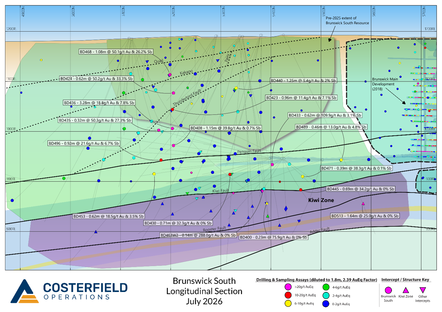
Figure 2. Long Section of the Brunswick South deposit with major vein target envelopes displayed, recent drill traces and > 6g/t AuEq new intercepts labelled. Older significant drill intercepts are displayed as smaller, unlabelled icons.

Figure 3. Brunswick South Deposit Plan Section with recent drill traces and > 6g/t AuEq new intercepts labelled. Older significant drill intercepts are displayed as smaller, unlabelled icons.
Figure 4. Cross section of the Brunswick South deposit with the Costerfield Leapfrog geology model sliced at 5200N, where the greatest number of new high-grade intercepts are located. The spread of intercepts away from the model slice is due to the strike of the Brunswick South deposit being approximately 15 degrees east of mine grid north (as seen in Figure 3).
Figure 5. Core tray photograph of the Brunswick South intercept of BD468 (50.1g/t gold and 26.2% antimony over 2.17m – ETW 1.08m) exhibiting the shear-associated, stibnite rich character typical to the Brunswick deposit above the Kiwi Zone. Zonation of sulphide wallrock alteration, from fine grained arsenopyrite proximal to the high grade veins to more distal blebby aggregates of pyrite may also be discerned. Photomicrographs of gold clusters within quartz and stibnite from the richest segment of the intercept are also shown.
Figure 6. Tray photograph and gold grades of the Kiwi Zone in drillhole BD513. The mineralisation is quartz-dominated in contrast to the upper Brunswick South structure, and occurs at a low angle to the west-dipping bedding, following the Kiwi Fault plane. This is dissimilar to K-R mineralisation beneath Brunswick Main where vertical veins are bound between the hangingwall and footwall planes of the fault slice due to the flattening of the Kiwi and Rooster Fault structures, being more aligned with a Youle-like geometry.
Future Plans
The information presented in this release has been integrated into the Costerfield mine schedule, and the commencement of capital development to access the area is scheduled for Q3 2026. Several targets have emerged as priority for further testing, which include:
- Further down-dip on the Kiwi Fault structure, which has not been effectively tested below 800RL to date. Applying the Youle thrust-hosted model to the structure, changes in dip and strike may host further economic pods of mineralisation, and Shepherd-like vertical veins suspected in the footwall are also being tested for.
- The gap in close-spaced drilling between the Brunswick and Brunswick South deposits will be tested in the near future, as the presence of grade pods here will likely influence the positioning of capital development.
- Southern extension or repetition of grade pods. BD407, the southernmost testing hole of this program stepped out 100 metres south of the previous bounding hole and intersected the Brunswick shear at 4884N. This intercept returned 9.4g/t gold over 0.30m (ETW 0.30m), demonstrating that the system has strong structural continuity and may form further shoots of economic mineralisation in this direction.
- A previously unknown mineralised structure was intercepted near surface from western drilling platforms. The best result to date from this structure is 8.4g/t gold and 1.3% antimony over 0.32m (ETW 0.31m) in BD475. Structural and grade continuity where tested to date is somewhat weak, although interpretation shows the vein to have an easterly dip, leading to an intersection axis close to the Brunswick South to Kiwi Zone transition. The highest prospectivity on this structure is likely towards the south, which will be further tested later in the year when private land access is favourable.
An updated Brunswick South resource will be announced as part of Alkane’s upcoming Resource and Reserves Statement.
This document has been authorised for release to the market by Nic Earner, Managing Director & CEO.
ABOUT ALKANE ‐ www.alkres.com ‐ ASX:ALK | TSX: ALK | OTCQX: ALKRY
Alkane (ASX:ALK; TSX:ALK; OTCQX:ALKRY) is an Australia-based gold and antimony producer with a portfolio of three operating mines across Australia and Sweden. The Company has a strong balance sheet and is positioned for further growth.
Alkane’s wholly owned producing assets are the Tomingley open pit and underground gold mine southwest of Dubbo in Central West New South Wales, the Costerfield gold and antimony underground mining operation northeast of Heathcote in Central Victoria, and the Björkdal underground gold mine northwest of Skellefteå in Sweden (approximately 750 km north of Stockholm). Ongoing near-mine regional exploration continues to grow resources at all three operations.
Alkane also owns the very large gold-copper porphyry Boda-Kaiser Project in Central West New South Wales and has outlined an economic development pathway in a Scoping Study. The Company has ongoing exploration within the surrounding Northern Molong Porphyry Project and is confident of further enhancing eastern Australia’s reputation as a significant gold, copper and antimony production region.
Competent Persons Statement
Certain information in this announcement relating to Exploration Results has been previously released to the ASX. Alkane confirms that it is not aware of any new information or data that materially affects the information included in those market announcements and that all material assumptions and technical parameters underpinning the estimates and Exploration Results in those announcements continue to apply and have not materially changed.
The information in this report that relates to the Costerfield Exploration Results is based on, and fairly represents, information compiled and verified by Mr Chris Davis. Mr Davis is a Chartered Professional (Geology) of the Australasian Institute of Mining and Metallurgy (MAusIMM CP(Geo)), and a Member of the Australian Institute of Geoscientists (MAIG).
Mr Davis has sufficient experience that is relevant to the style of mineralisation and type of deposit under consideration and to the activity being undertaken to qualify as a Competent Person as defined in the 2012 Edition of the “Australian Code for Reporting of Exploration Results, Mineral Resources, and Ore Reserves” (JORC Code).
For the purposes of National Instrument 43-101 – Standards of Disclosure for Mineral Projects (‘NI 43-101’), the scientific and technical information contained in this announcement relating to the Costerfield Exploration Results has been prepared under the supervision of, and approved by, Mr Chris Davis, who is a “qualified person” as defined in NI 43-101. Mr Davis is employed by Alkane as Chief Geologist and, as an employee of Alkane, is not considered independent of Alkane within the meaning of NI 43-101.
Mr Davis consents to the inclusion in this report of the matters based on his information in the form and context in which they appear.
Cautionary Note Regarding Forward-Looking Information and Statements
This announcement contains certain forward-looking information and forward-looking statements within the meaning of applicable securities legislation and may include future-oriented financial information or financial outlook information (collectively Forward-Looking Information). Actual results and outcomes may vary materially from the amounts set out in any Forward-Looking Information. As well, Forward-Looking Information may relate to: future outlook and anticipated events; expectations regarding exploration potential; production capabilities and future financial or operating performance, including AISC, investment returns, margins and share price performance; production and cost guidance and the timing thereof; issuing updated resources and reserves estimate and the timing thereof; the potential of Alkane to meet industry targets, public profile and expectations; and future plans, projections, objectives, estimates and forecasts and the timing related thereto.
Forward-Looking Information is generally identified by the use of words like “will”, “create”, “enhance”, “improve”, “potential”, “expect”, “upside”, “growth” and similar expressions and phrases or statements that certain actions, events or results “may”, “could”, or “should”, or the negative connotation of such terms, are intended to identify Forward-Looking Information.
Although Alkane believes that the expectations reflected in the Forward-Looking Information are reasonable, undue reliance should not be placed on Forward-Looking Information since no assurance can be provided that such expectations will prove to be correct. Forward-Looking Information is based on information available at the time those statements are made and/or good faith belief of the officers and directors of Alkane as of that time with respect to future events and are subject to risks and uncertainties that could cause actual results to differ materially from those expressed in or suggested by the Forward-Looking Information. Forward-Looking Information involves numerous risks and uncertainties. Such factors include, without limitation: risks relating to changes in the gold and antimony price.
Forward-Looking Information is designed to help readers understand Alkane’s views as of that time with respect to future events and speak only as of the date they are made. Except as required by applicable law, Alkane assumes no obligation to update or to publicly announce the results of any change to any forward-looking statement contained or incorporated by reference herein to reflect actual results, future events or developments, changes in assumptions or changes in other factors affecting the Forward-looking Information. If Alkane updates any one or more forward-looking statements, no inference should be drawn that the company will make additional updates with respect to those or other Forward-looking Information. All Forward-Looking Information contained in this announcement is expressly qualified in its entirety by this cautionary statement.
Disclaimer
Alkane has prepared this announcement based on information available to it. No representation or warranty, express or implied, is made as to the fairness, accuracy, completeness or correctness of the information, opinions or conclusions contained in this announcement. To the maximum extent permitted by law, none of Alkane, its directors, officers, employees, associates, advisers and agents, nor any other person accepts any liability, including, without limitation, any liability arising from fault or negligence on the part of any of them or any other person, for any loss arising from the use of this announcement or its contents or otherwise arising in connection with it.
This announcement is not an offer, invitation, solicitation, or other recommendation with respect to the subscription for, purchase or sale of any security, and neither this announcement nor anything in it shall form the basis of any contract or commitment whatsoever.
APPENDIX 1 – Tabulated Drilling Results
Significant intercepts from the Brunswick South infill and growth drilling programs at Costerfield
| Drill Hole ID | From (m) | To (m) | Interval (m) | Estimated True Width (m) | Au (g/t) | Sb (%) | Gold-equiv. grade diluted to 1.8 m (g/t) | Interpreted Vein |
| BD402 | 257.47 | 258.94 | 1.47 | 1.41 | 1.9 | 0.1 | 1.7 | Brunswick South |
| BD403 | 392.38 | 392.66 | 0.28 | 0.23 | 5.4 | 1.4 | 1.1 | Brunswick South |
| BD404 | 419.23 | 419.37 | 0.14 | 0.12 | 2.3 | 0.1 | 0.2 | Brunswick South |
| BD405 | 655.00 | 655.84 | 0.84 | 0.83 | 8.5 | 0.7 | 4.7 | Brunswick South |
| BD407 | 644.97 | 645.27 | 0.30 | 0.30 | 9.4 | 0.0 | 1.6 | Brunswick South |
| BD408 | 379.67 | 380.97 | 1.30 | 1.15 | 39.8 | 0.7 | 26.6 | Brunswick South |
| BD409 | 417.99 | 418.11 | 0.12 | 0.09 | 28.4 | 12.7 | 3.0 | Brunswick South |
| BD410 | 441.50 | 442.00 | 0.50 | 0.34 | 8.8 | 3.1 | 3.0 | Brunswick South |
| BD419 | 189.42 | 189.81 | 0.39 | 0.25 | 1.6 | 0.1 | 0.3 | Brunswick South |
| BD420 | 174.70 | 174.88 | 0.18 | 0.12 | 2.4 | 0.0 | 0.2 | Brunswick South |
| BD420W1 | 172.77 | 173.23 | 0.46 | 0.33 | 0.7 | 0.0 | 0.1 | Brunswick South |
| BD421 | 153.66 | 153.84 | 0.18 | 0.14 | 0.9 | 0.3 | 0.1 | Brunswick South |
| BD422 | 217.45 | 218.78 | 1.33 | 0.73 | 2.3 | 0.1 | 1.1 | Brunswick South |
| BD423 | 198.51 | 200.05 | 1.54 | 0.96 | 11.4 | 7.1 | 15.0 | Brunswick South |
| BD424 | 176.30 | 177.16 | 0.86 | 0.62 | 50.2 | 33.3 | 44.7 | Brunswick South |
| BD425 | 230.40 | 233.00 | 2.60 | 1.76 | 1.2 | 0.2 | 1.6 | Brunswick South |
| BD426 | 264.14 | 264.42 | 0.28 | 0.18 | 1.5 | 1.5 | 0.5 | Brunswick South |
| BD427 | 264.40 | 264.53 | 0.13 | 0.08 | 0.9 | 0.0 | 0.0 | Brunswick South |
| BD428 | 244.65 | 245.37 | 0.72 | 0.49 | 2.3 | 0.0 | 0.6 | Brunswick South |
| BD429 | 239.86 | 240.97 | 1.11 | 1.01 | 2.0 | 0.0 | 1.2 | Brunswick South |
| BD430 | 220.47 | 221.40 | 0.93 | 0.71 | 32.3 | 0.0 | 12.8 | Brunswick South |
| BD431 | 202.01 | 202.25 | 0.24 | 0.19 | 5.4 | 0.0 | 0.6 | Brunswick South |
| BD432 | 180.15 | 182.40 | 2.25 | 1.98 | 2.0 | 0.0 | 2.0 | Brunswick South |
| BD433 | 162.37 | 163.02 | 0.65 | 0.62 | 109.9 | 3.1 | 40.1 | Brunswick South |
| BD434 | 299.58 | 300.53 | 0.95 | 0.55 | 0.5 | 0.8 | 0.7 | Brunswick South |
| BD435 | 312.30 | 312.85 | 0.55 | 0.32 | 50.3 | 27.3 | 20.4 | Brunswick South |
| BD436 | 285.06 | 290.53 | 5.47 | 3.28 | 18.8 | 7.8 | 37.4 | Brunswick South |
| BD437 | 141.13 | 141.55 | 0.42 | 0.33 | 0.7 | 0.4 | 0.3 | Brunswick South |
| BD438 | 185.40 | 185.90 | 0.50 | 0.29 | 1.0 | 0.0 | 0.2 | Brunswick South |
| BD440 | 149.83 | 151.53 | 1.70 | 1.25 | 5.4 | 2.0 | 7.1 | Brunswick South |
| BD441 | 186.18 | 186.91 | 0.73 | 0.43 | 7.3 | 2.2 | 3.0 | Brunswick South |
| BD442 | 275.68 | 278.28 | 2.60 | 1.21 | 1.8 | 0.0 | 1.3 | Brunswick South |
| BD443 | 152.06 | 154.52 | 2.46 | 2.40 | 1.7 | 0.1 | 2.0 | Brunswick South |
| BD444 | 153.15 | 153.30 | 0.15 | 0.15 | 18.7 | 2.5 | 2.0 | Brunswick South |
| BD445 | 174.38 | 175.12 | 0.74 | 0.69 | 34.2 | 0.0 | 13.1 | Brunswick South |
| BD446 | 194.36 | 194.50 | 0.14 | 0.12 | 30.4 | 0.0 | 2.0 | Brunswick South |
| BD447 | 217.82 | 218.35 | 0.53 | 0.26 | 3.1 | 0.0 | 0.4 | Brunswick South |
| BD452 | 352.62 | 353.44 | 0.82 | 0.44 | 0.5 | 1.1 | 0.8 | Brunswick South |
| BD453 | 310.65 | 311.84 | 1.19 | 0.62 | 18.5 | 3.5 | 9.2 | Brunswick South |
| BD454 | 276.00 | 276.32 | 0.32 | 0.14 | 1.3 | 0.1 | 0.1 | Brunswick South |
| BD455 | 223.00 | 223.50 | 0.50 | 0.28 | 17.4 | 4.6 | 4.4 | Brunswick South |
| BD456 | 193.14 | 194.44 | 1.30 | 0.82 | 1.6 | 0.1 | 0.8 | Brunswick South |
| BD457W1 | 169.25 | 169.60 | 0.35 | 0.26 | 7.8 | 12.5 | 5.5 | Brunswick South |
| BD458 | 206.14 | 206.63 | 0.49 | 0.31 | 13.4 | 3.7 | 3.8 | Brunswick South |
| BD459 | 182.80 | 182.98 | 0.18 | 0.12 | 9.1 | 3.7 | 1.2 | Brunswick South |
| BD461 | 321.04 | 321.20 | 0.16 | 0.08 | 1.5 | 0.0 | 0.1 | Brunswick South |
| BD463W2 | 184.90 | 185.00 | 0.10 | 0.09 | 43.3 | 0.0 | 2.1 | Brunswick South |
| BD466 | 98.01 | 98.15 | 0.14 | 0.07 | 13.5 | 12.6 | 1.6 | Brunswick South |
| BD467 | 87.64 | 88.00 | 0.36 | 0.21 | 0.1 | 0.2 | 0.1 | Brunswick South |
| BD468 | 95.90 | 98.07 | 2.17 | 1.08 | 50.1 | 26.2 | 67.2 | Brunswick South |
| BD471 | 160.44 | 160.84 | 0.40 | 0.39 | 38.3 | 0.1 | 8.2 | Brunswick South |
| BD473 | 248.64 | 248.97 | 0.33 | 0.21 | 0.8 | 0.0 | 0.1 | Brunswick South |
| BD475 | 158.52 | 158.72 | 0.20 | 0.15 | 12.4 | 6.9 | 2.4 | Brunswick South |
| BD476 | 226.81 | 227.05 | 0.24 | 0.19 | 3.2 | 0.1 | 0.3 | Brunswick South |
| BD478 | 78.98 | 79.47 | 0.49 | 0.30 | 0.5 | 0.1 | 0.1 | Brunswick South |
| BD487 | 81.95 | 82.20 | 0.25 | 0.14 | 7.0 | 4.2 | 1.4 | Brunswick South |
| BD489 | 173.56 | 174.10 | 0.54 | 0.46 | 13.0 | 4.8 | 6.3 | Brunswick South |
| BD492 | 264.08 | 264.26 | 0.18 | 0.13 | 0.4 | 0.0 | 0.0 | Brunswick South |
| BD493 | 321.33 | 322.00 | 0.67 | 0.26 | 0.0 | 0.0 | 0.0 | Brunswick South |
| BD494 | 98.72 | 101.73 | 3.01 | 1.54 | 3.9 | 0.7 | 4.9 | Brunswick South |
| BD495 | 97.31 | 97.81 | 0.50 | 0.26 | 11.7 | 3.1 | 2.7 | Brunswick South |
| BD496 | 294.00 | 295.65 | 1.65 | 0.92 | 21.6 | 6.7 | 19.2 | Brunswick South |
| BD499 | 277.84 | 278.04 | 0.20 | 0.12 | 0.5 | 0.3 | 0.1 | Brunswick South |
| BD500 | 226.22 | 227.18 | 0.96 | 0.52 | 1.8 | 2.4 | 2.2 | Brunswick South |
| BD501 | 163.81 | 164.30 | 0.49 | 0.46 | 2.8 | 0.0 | 0.7 | Brunswick South |
| BD502 | 230.06 | 230.36 | 0.30 | 0.21 | 3.3 | 1.1 | 0.7 | Brunswick South |
| BD503 | 280.79 | 282.56 | 1.77 | 1.11 | 1.8 | 0.2 | 1.4 | Brunswick South |
| BD508 | 437.01 | 437.25 | 0.24 | 0.08 | 13.2 | 9.8 | 1.7 | Brunswick South |
| BD512W1 | 209.53 | 209.96 | 0.43 | 0.34 | 1.8 | 0.0 | 0.3 | Brunswick South |
| BD396 | 404.20 | 404.60 | 0.40 | 0.28 | 12.4 | 0.0 | 1.9 | Kiwi Zone |
| BD400 | 446.91 | 447.14 | 0.23 | 0.23 | 75.9 | 0.0 | 9.5 | Kiwi Zone |
| BD401 | 458.33 | 460.81 | 2.48 | 2.34 | 0.0 | 0.0 | 0.1 | Kiwi Zone |
| BD414 | 530.00 | 534.37 | 4.37 | 3.55 | 0.0 | 0.0 | 0.1 | Kiwi Zone |
| BD416 | 452.50 | 452.70 | 0.20 | 0.20 | 46.0 | 0.0 | 5.1 | Kiwi Zone |
| BD418 | 449.88 | 450.40 | 0.52 | 0.52 | 2.4 | 0.0 | 0.7 | Kiwi Zone |
| BD449 | 283.00 | 284.40 | 1.40 | 0.90 | 1.7 | 0.0 | 0.8 | Kiwi Zone |
| BD450 | 258.45 | 259.13 | 0.68 | 0.12 | 0.4 | 0.0 | 0.0 | Kiwi Zone |
| BD462 | 312.26 | 312.71 | 0.45 | 0.26 | 0.5 | 0.0 | 0.1 | Kiwi Zone |
| BD465 | 216.73 | 217.41 | 0.68 | 0.15 | 2.3 | 0.0 | 0.2 | Kiwi Zone |
| BD481AW1 | 438.44 | 439.95 | 1.51 | 1.51 | 0.8 | 0.0 | 0.7 | Kiwi Zone |
| BD482 | 431.78 | 432.78 | 1.00 | 0.99 | 1.9 | 0.1 | 1.2 | Kiwi Zone |
| BD483 | 451.76 | 452.62 | 0.86 | 0.85 | 0.6 | 0.0 | 0.3 | Kiwi Zone |
| BD513 | 388.20 | 388.32 | 1.70 | 1.64 | 25.0 | 0.0 | 22.8 | Kiwi Zone |
| BD396 | 425.90 | 426.24 | 0.34 | 0.22 | 27.4 | 0.1 | 3.3 | Other |
| BD397 | 364.80 | 365.15 | 0.35 | 0.21 | 14.6 | 0.0 | 1.7 | Other |
| BD400 | 448.10 | 448.40 | 0.30 | 0.27 | 11.7 | 0.0 | 1.7 | Other |
| BD403 | 395.46 | 395.64 | 0.18 | 0.13 | 7.0 | 2.9 | 1.0 | Other |
| BD407 | 74.31 | 74.42 | 0.11 | 0.11 | 17.9 | 13.2 | 3.0 | Other |
| BD408 | 377.00 | 378.00 | 1.00 | 0.72 | 2.8 | 1.0 | 2.1 | Other |
| BD410 | 75.96 | 77.86 | 1.90 | 1.22 | 2.6 | 0.0 | 1.8 | Other |
| BD416 | 145.94 | 147.12 | 1.18 | 0.14 | 5.6 | 2.7 | 1.0 | Other |
| BD423 | 201.55 | 201.65 | 0.10 | 0.08 | 24.9 | 4.5 | 1.5 | Other |
| BD426 | 260.64 | 260.94 | 0.30 | 0.28 | 5.8 | 1.8 | 1.6 | Other |
| BD430 | 211.10 | 211.93 | 0.83 | 0.72 | 5.7 | 0.0 | 2.3 | Other |
| BD430 | 215.36 | 220.47 | 5.11 | 4.43 | 5.8 | 0.0 | 5.8 | Other |
| BD435 | 301.28 | 301.45 | 0.17 | 0.13 | 13.7 | 11.4 | 3.0 | Other |
| BD440 | 154.10 | 155.59 | 1.49 | 0.90 | 7.5 | 1.1 | 5.1 | Other |
| BD440 | 157.67 | 157.81 | 0.14 | 0.09 | 4.9 | 7.4 | 1.2 | Other |
| BD442 | 269.67 | 270.21 | 0.54 | 0.43 | 4.6 | 0.0 | 1.1 | Other |
| BD442 | 271.68 | 272.50 | 0.82 | 0.45 | 4.8 | 0.3 | 1.3 | Other |
| BD446 | 194.74 | 196.28 | 1.54 | 1.25 | 3.0 | 0.0 | 2.1 | Other |
| BD446 | 198.52 | 200.46 | 1.94 | 1.55 | 3.1 | 0.0 | 2.7 | Other |
| BD446 | 203.36 | 203.80 | 0.44 | 0.34 | 7.4 | 0.0 | 1.4 | Other |
| BD450 | 245.80 | 245.91 | 0.11 | 0.09 | 67.4 | 0.0 | 3.4 | Other |
| BD455 | 223.00 | 223.50 | 0.50 | 0.22 | 17.4 | 4.6 | 3.4 | Other |
| BD458 | 205.06 | 205.74 | 0.68 | 0.59 | 3.2 | 0.1 | 1.1 | Other |
| BD463 | 185.09 | 185.40 | 0.31 | 0.29 | 32.2 | 0.0 | 5.2 | Other |
| BD463 | 187.00 | 187.58 | 0.58 | 0.51 | 4.0 | 0.0 | 1.1 | Other |
| BD463 | 190.23 | 191.23 | 1.00 | 0.89 | 2.6 | 0.0 | 1.3 | Other |
| BD463 | 196.78 | 197.38 | 0.60 | 0.54 | 3.9 | 0.0 | 1.2 | Other |
| BD463W2 | 186.10 | 188.90 | 2.80 | 1.69 | 4.1 | 0.0 | 3.8 | Other |
| BD463W2 | 192.07 | 192.78 | 0.71 | 0.29 | 6.9 | 0.0 | 1.1 | Other |
| BD463W2 | 197.00 | 197.16 | 0.16 | 0.14 | 288.0 | 0.0 | 22.8 | Other |
| BD465 | 226.20 | 226.76 | 0.56 | 0.47 | 4.9 | 0.0 | 1.3 | Other |
| BD468 | 98.07 | 98.34 | 0.27 | 0.14 | 7.6 | 3.1 | 1.2 | Other |
| BD473 | 234.31 | 234.45 | 0.14 | 0.12 | 51.4 | 0.0 | 3.5 | Other |
| BD473 | 276.21 | 276.69 | 0.48 | 0.33 | 18.7 | 1.3 | 4.0 | Other |
| BD475 | 146.62 | 146.75 | 0.13 | 0.11 | 18.3 | 4.2 | 1.8 | Other |
| BD475 | 393.14 | 393.46 | 0.32 | 0.32 | 8.4 | 1.3 | 2.0 | Other |
| BD476 | 227.75 | 228.16 | 0.41 | 0.35 | 4.9 | 0.8 | 1.3 | Other |
| BD478 | 59.75 | 59.95 | 0.20 | 0.07 | 20.2 | 6.6 | 1.4 | Other |
| BD489 | 174.10 | 174.85 | 0.75 | 0.65 | 8.9 | 0.1 | 3.3 | Other |
| BD500 | 226.22 | 226.60 | 0.38 | 0.20 | 2.2 | 5.1 | 1.6 | Other |
| BD502 | 229.01 | 229.60 | 0.59 | 0.74 | 4.9 | 0.1 | 2.1 | Other |
Notes
1. The AuEq (gold equivalent) grade is calculated using the following formula:
AuEq =Au (g/t) + 2.39 x Sb (%)AuEq g per t=Au g per t+Sb%×
And the AuEq factor of 2.39 is calculated:
- at a gold price of US$2,500/oz
- an antimony price of US$19,000/t
- with 2025 predicted metal recoveries of 91% Au and 92% Sb.
Prices and recoveries used: Au $/oz = 2,500; Sb $/t = 19,000; Au Recovery = 91% and; Sb Recovery = 92%
2. Composites that are not interpreted to be connected to a major vein and are below 1 g/t AuEq when diluted to 1.8m are not considered significant and are not recorded here.
Drill hole collar details from the Brunswick South drilling program at Costerfield:
| Hole ID | Northing | Easting | Elevation | Depth | Azimuth | Dip | Date Completed |
| BD396 | 5502 | 14989 | 943 | 444.9 | 83.0 | -53.6 | 3/08/2025 |
| BD397 | 5503 | 14988 | 943 | 488.3 | 230.4 | -12.9 | 21/08/2025 |
| BD400 | 5344 | 14386 | 1190 | 540.0 | 67.1 | -57.3 | 12/10/2025 |
| BD401 | 5337 | 14386 | 1191 | 637.6 | 263.3 | -20.3 | 31/08/2025 |
| BD402 | 5503 | 14988 | 944 | 371.4 | 78.6 | -50.9 | 2/09/2025 |
| BD403 | 5339 | 14386 | 1190 | 484.5 | 121.2 | -47.9 | 10/09/2025 |
| BD404 | 5343 | 14387 | 1190 | 547.5 | 265.0 | -0.4 | 4/10/2025 |
| BD405 | 4801 | 15237 | 968 | 698.3 | 102.8 | -40.1 | 18/10/2025 |
| BD407 | 4801 | 15237 | 968 | 985.3 | 82.6 | -42.3 | 16/11/2025 |
| BD408 | 5339 | 14386 | 1190 | 418.7 | 283.3 | -11.6 | 22/10/2025 |
| BD409 | 5339 | 14386 | 1190 | 445.1 | 278.8 | -14.4 | 28/10/2025 |
| BD410 | 5338 | 14386 | 1191 | 481.3 | 115.5 | -41.0 | 7/11/2025 |
| BD414 | 5343 | 14386 | 1190 | 620.0 | 127.4 | -39.4 | 20/11/2025 |
| BD416 | 5344 | 14385 | 1190 | 529.9 | 136.5 | -38.2 | 6/12/2025 |
| BD418 | 5343 | 14386 | 1190 | 545.3 | 141.7 | -48.2 | 17/12/2025 |
| BD419 | 5292 | 14566 | 1191 | 221.2 | 79.0 | -53.8 | 21/12/2025 |
| BD420 | 5292 | 14565 | 1191 | 195.0 | 95.0 | -57.6 | 29/12/2025 |
| BD420W1 | 5292 | 14565 | 1191 | 181.9 | 102.8 | -54.3 | 20/12/2025 |
| BD421 | 5292 | 14566 | 1191 | 195.3 | 102.8 | -48.0 | 3/01/2026 |
| BD422 | 5291 | 14564 | 1191 | 248.0 | 102.8 | -48.0 | 14/01/2026 |
| BD423 | 5290 | 14564 | 1191 | 226.5 | 103.5 | -39.3 | 18/01/2026 |
| BD424 | 5290 | 14564 | 1191 | 202.5 | 123.6 | -54.4 | 22/01/2026 |
| BD425 | 5398 | 14868 | 946 | 287.7 | 129.1 | -48.5 | 13/01/2026 |
| BD426 | 5398 | 14868 | 946 | 323.7 | 128.4 | -40.8 | 8/02/2026 |
| BD427 | 5397 | 14868 | 946 | 306.6 | 230.5 | 3.0 | 22/01/2026 |
| BD428 | 5422 | 14876 | 946 | 281.4 | 225.7 | -2.2 | 13/01/2026 |
| BD429 | 5422 | 14876 | 945 | 275.6 | 227.2 | -9.8 | 20/01/2026 |
| BD430 | 5422 | 14876 | 946 | 239.8 | 235.8 | -13.1 | 20/02/2026 |
| BD431 | 5423 | 14876 | 946 | 229.9 | 234.0 | -7.1 | 24/01/2026 |
| BD432 | 5423 | 14875 | 946 | 209.1 | 241.6 | -7.9 | 11/04/2026 |
| BD433 | 5423 | 14875 | 946 | 188.1 | 241.9 | 3.4 | 3/04/2026 |
| BD434 | 5397 | 14868 | 946 | 335.5 | 251.8 | 0.3 | 13/02/2026 |
| BD435 | 5397 | 14868 | 947 | 347.3 | 262.0 | -3.5 | 2/02/2026 |
| BD436 | 5397 | 14868 | 947 | 320.4 | 221.7 | 3.0 | 27/01/2026 |
| BD437 | 5381 | 14592 | 1193 | 166.3 | 221.2 | 9.6 | 6/02/2026 |
| BD438 | 5382 | 14593 | 1193 | 233.0 | 224.6 | 11.7 | 4/02/2026 |
| BD440 | 5379 | 14592 | 1193 | 229.5 | 90.1 | -39.7 | 17/02/2026 |
| BD441 | 5380 | 14592 | 1193 | 233.3 | 90.4 | -56.0 | 12/02/2026 |
| BD442 | 5380 | 14591 | 1193 | 293.5 | 115.0 | -45.5 | 9/02/2026 |
| BD443 | 5424 | 14874 | 947 | 235.0 | 115.0 | -54.5 | 27/01/2026 |
| BD444 | 5424 | 14874 | 946 | 187.4 | 116.0 | -66.9 | 31/01/2026 |
| BD445 | 5425 | 14874 | 945 | 237.6 | 269.2 | 9.0 | 6/02/2026 |
| BD446 | 5423 | 14875 | 945 | 229.0 | 274.8 | -4.2 | 14/02/2026 |
| BD447 | 5381 | 14592 | 1193 | 274.9 | 281.2 | -21.6 | 31/01/2026 |
| BD449 | 5422 | 14876 | 945 | 335.8 | 248.6 | -13.4 | 28/02/2026 |
| BD450 | 5423 | 14875 | 945 | 289.1 | 90.4 | -62.1 | 7/03/2026 |
| BD452 | 5397 | 14868 | 946 | 401.3 | 237.8 | -21.0 | 4/03/2026 |
| BD453 | 5397 | 14868 | 946 | 350.6 | 245.7 | -24.0 | 23/02/2026 |
| BD454 | 5380 | 14591 | 1193 | 290.4 | 217.0 | 6.3 | 20/02/2026 |
| BD455 | 5121 | 14773 | 1185 | 239.3 | 221.5 | -5.2 | 5/03/2026 |
| BD456 | 5121 | 14772 | 1185 | 236.1 | 116.7 | -62.9 | 7/03/2026 |
| BD457 | 5121 | 14771 | 1185 | 625.3 | 265.3 | -53.0 | 19/03/2026 |
| BD457W1 | 5121 | 14771 | 1185 | 175.4 | 265.2 | -47.7 | 21/03/2026 |
| BD458 | 5122 | 14773 | 1185 | 238.8 | 262.4 | -40.0 | 26/02/2026 |
| BD459 | 5123 | 14773 | 1185 | 245.0 | 262.4 | -40.0 | 1/03/2026 |
| BD461 | 5397 | 14868 | 946 | 344.8 | 286.6 | -55.0 | 11/03/2026 |
| BD462 | 5398 | 14868 | 945 | 419.9 | 290.5 | -48.9 | 27/03/2026 |
| BD463 | 5423 | 14875 | 945 | 227.5 | 221.6 | -13.8 | 12/03/2026 |
| BD463W2 | 5423 | 14875 | 945 | 209.3 | 226.5 | -21.0 | 16/03/2026 |
| BD465 | 5424 | 14874 | 945 | 274.8 | 257.3 | -18.1 | 22/03/2026 |
| BD466 | 5251 | 14634 | 1188 | 125.6 | 257.3 | -18.1 | 12/03/2026 |
| BD467 | 5249 | 14634 | 1188 | 110.6 | 272.0 | -25.5 | 16/03/2026 |
| BD468 | 5248 | 14633 | 1188 | 130.0 | 49.1 | -42.9 | 18/03/2026 |
| BD471 | 5425 | 14874 | 945 | 208.5 | 90.4 | -56.4 | 26/03/2026 |
| BD473 | 5398 | 14867 | 945 | 300.9 | 143.8 | -50.0 | 3/04/2026 |
| BD475 | 5123 | 14772 | 1185 | 600.0 | 285.0 | -12.2 | 31/03/2026 |
| BD476 | 5422 | 14875 | 947 | 250.9 | 231.1 | -13.8 | 30/03/2026 |
| BD478 | 5153 | 14710 | 1186 | 110.3 | 291.6 | -39.8 | 26/03/2026 |
| BD481A | 5337 | 14403 | 1189 | 492.9 | 240.5 | 14.0 | 1/05/2026 |
| BD481AW1 | 5337 | 14403 | 1189 | 459.1 | 272.5 | -49.0 | 3/05/2026 |
| BD482 | 5337 | 14403 | 1189 | 494.1 | 81.8 | -58.8 | 19/04/2026 |
| BD483 | 5337 | 14403 | 1189 | 518.3 | 81.8 | -58.8 | 15/05/2026 |
| BD487 | 5248 | 14633 | 1188 | 107.2 | 143.9 | -41.3 | 24/03/2026 |
| BD488 | 5426 | 14875 | 947 | 205.4 | 295.3 | 18.2 | 29/04/2026 |
| BD489 | 5426 | 14876 | 946 | 206.3 | 310.8 | -0.7 | 15/04/2026 |
| BD490 | 5116 | 14773 | 1186 | 319.9 | 221.9 | -45.5 | 30/04/2026 |
| BD491 | 5117 | 14774 | 1186 | 446.3 | 223.6 | -61.8 | 26/04/2026 |
| BD492 | 5117 | 14772 | 1186 | 280.9 | 240.0 | -51.5 | 11/04/2026 |
| BD493 | 5118 | 14772 | 1186 | 413.4 | 240.8 | -65.9 | 16/04/2026 |
| BD493W1 | 5118 | 14772 | 1186 | 366.0 | 240.8 | -65.9 | 18/04/2026 |
| BD494 | 5153 | 14711 | 1186 | 125.2 | 261.5 | -55.2 | 31/03/2026 |
| BD495 | 5152 | 14710 | 1186 | 118.9 | 241.5 | -45.9 | 7/04/2026 |
| BD496 | 5397 | 14868 | 946 | 344.4 | 220.7 | -0.5 | 21/04/2026 |
| BD499 | 5397 | 14868 | 946 | 311.7 | 223.1 | -4.4 | 10/04/2026 |
| BD500 | 5121 | 14773 | 1185 | 290.3 | 276.0 | -56.5 | 4/04/2026 |
| BD501 | 5425 | 14875 | 945 | 226.4 | 293.9 | -14.9 | 9/04/2026 |
| BD502 | 5422 | 14876 | 946 | 269.5 | 233.1 | 7.1 | 19/04/2026 |
| BD503 | 5422 | 14876 | 946 | 313.7 | 226.5 | 7.7 | 25/04/2026 |
| BD508 | 5397 | 14868 | 946 | 500.6 | 211.1 | 2.1 | 5/05/2026 |
| BD512 | 5427 | 14876 | 946 | 234.2 | 322.5 | -1.0 | 4/05/2026 |
| BD512W1 | 5427 | 14876 | 946 | 221.3 | 322.5 | -1.0 | 6/05/2026 |
| BD513 | 5425 | 14593 | 1193 | 458.6 | 30.2 | -60.6 | 11/05/2026 |
Notes:
- Coordinate System: Costerfield Local Mine Grid
Appendix 2 – JORC Code, 2012 Edition – Table 1
Section 1 Sampling Techniques and Data
| Criteria | JORC Code explanation | Commentary |
| Sampling techniques |
| Sampling of Au and Sb mineralisation is from diamond drill core (HQ2, NQ2 and LTK48) and underground channel sampling (face samples). Due to the discrete mineralisation of the deposit, not all diamond drill core was required to be sampled. Sample intervals were determined and marked on the core by Alkane geologists using the following general rules:
Diamond core sampling intervals were standardised wherever possible and ranged from 5 cm to 1 m in length. Diamond drill core samples have been cut in half using the orientation line or cut line, with a consistent side of the cut core selected for assay to ensure unbiased sampling. Whole core was sampled for LTK48 and Shepherd gold-rich zones. The methodology was validated by the Costerfield QA/QC protocols. No sampling instruments required calibration. Channel samples were collected perpendicular to the dip of the mineralisation, extending from the footwall to the hangingwall. Where multiple mineralised structures were present in the face, intervening waste was also sampled. Sample lengths were measured on the face and ranged from 5 cm to 1 m across mineralisation, with typical sample weights between 1 kg and 3 kg. Each sample was collected using a geological hammer, placed into a pre-numbered sample bag with a unique identifier, and the face was labelled, dated, and photographed. Assays were completed by On Site in Bendigo, which is independent of Alkane and holds current ISO/IEC 17025 accreditation. The general methods were as follows:
|
| Drilling techniques |
| Star West Drilling Pty Ltd and Deepcore Drilling were the drilling contractors utilised for this project, from both surface and underground drilling platforms. Diamond drilling has been predominantly completed using LM90 drill rigs utilising HQ2 and NQ2 diameters, with HQ3 employed where ground conditions or noise considerations dictate. Core orientation is performed each run, typically using an AXIS Champ Ori kit. |
| Drill sample recovery |
| Diamond drilling was routinely checked for core loss during both drilling and sampling. Core loss blocks were added by drillers and then checked by geologists or field technicians when the core was measured, and depth marks made. If problems were encountered with recovery and core block depths, the drill shift supervisor was advised and depth marking stopped until the issue was rectified. No relationship between grade and sample recovery has been established. Ore zones with poor recovery are redrilled until a representative sample is achieved. |
| Logging |
| All drill core was geologically logged as full core for the relevant rock quality designation, lithology, structural data, and sample intervals. Data capture was digital into the AcQuire software using validated codes. All drill core was photographed wet with high resolution photographs stored on the site’s server, which is routinely backed-up. |
| Sub-sampling techniques and sample preparation |
| Diamond core sampling intervals were standardised wherever possible and ranged from 5 cm to 1 m in length. Diamond drill core samples have been halved for sampling (whole core sampled if representative halving was not possible) guided by the orientation line or a cut line, with a consistent side of the cut core selected for assay to ensure unbiased sampling. The following sample preparation activities were undertaken by Alkane staff for both diamond drill core and underground channel samples:
The following sample preparation activities were undertaken by On Site staff:
For fire assay and base metal samples:
For photon assay:
For all methods:
A quarterly check-assay program is in place to monitor the representative nature of sampling and assay methodology. |
| Quality of assay data and laboratory tests |
| The assaying protocols used at Costerfield have been developed to ensure expected levels of accuracy and precision are met for the style of mineralisation tested and utilised in the MRE. Samples were assayed for gold, antimony, arsenic, and iron using representative partial digest methodologies:
The quality control procedures utilised at Costerfield used CRMs prepared by commercial laboratories Geostats and OREAS. CRMs were either prepared using Costerfield material or were otherwise matrix matched to ensure a representative nature. At least one CRM was submitted with every batch of diamond core samples and typically at a rate of 1 standard per 25 samples. Up to six CRMs covering the expected ranges of gold and antimony mineralisation were in rotation during routine sampling. An assay result for a CRM was considered acceptable when the returned assay fell within three standard deviations of the CRM certification grade. Outside this range, the CRM assay was considered to have failed and all significant mineralised samples within the batch were re-assayed, where significant grades were defined as mineralised samples that may have a material-impact in future resource estimates. All actions or outcomes were recorded as comments in the QA/QC register. Alkane submitted uncrushed samples of basalt as blank material sourced from Geostats into assay sample lots, at a rate of 1 in every 30 samples, to test for contamination during sample preparation. The failure threshold for gold is 0.10 g/t, which was chosen since it represents ten times the detection limit of 0.01 g/t for AAS. The failure threshold for antimony is 0.05%, which was chosen for being five times the detection limit of 0.01% for AAS. Pulp duplicates were collected routinely at a rate of 1:22 by On Site and submitted with the primary sample for analysis. Precision was in line for the expected a variance in both gold and antimony. Umpire laboratory checks to three additional commercial assay laboratories are completed each year covering all new assays generated at the property. |
| Verification of sampling and assaying |
| Sampling intervals and numbering were validated by geologists prior to cutting, with pre-numbered sampling bags systematically used by the field technicians to ensure the correct sample was submitted under each ID. Internal validation of significant intercepts was completed by the exploration and senior geologists. Photographs, logging, sample weights and assay results were checked to ensure manual errors were eliminated. Key intercepts at Costerfield were also validated by the Resource Geologist and Competent Person during the interpretation and modelling or the Costerfield resource estimation. Assay and sampling data was automatically uploaded into the Acquire database system and QA/QC validated at the point of upload. Any issues were entered into a QA/QC register and resolved before data acceptance. Alkane staff conduct periodic visits to the On Site Laboratory in Bendigo and meet regularly with the Lab managers. In early 2023 a review was conducted by a third party (RSC Consulting Pty Ltd) to ensure the practices are appropriate. Nothing of major concern was found. Twinned holes are typically only drilled intentionally to get full recovery of an ore zone when the initial hole has core loss. There are inadvertent twinned intercepts within the database, particularly when the collar position is close to the mineralisation. Twinned intercepts provide consistent correlation of structure and mineralisation character however due to the short range grade variability common structurally controlled gold systems, may not have the same mineralisation tenor. No adjustment has been made to the assay data. |
| Location of data points |
| Drill hole collar locations have been determined by differential GPS or theodolite surveying methods, either by external surveyors or Alkane surveyors. A digital report is created and entered into the acQuire Database. Data entry accuracy is validated against a LiDAR topographic map and high-resolution satellite imagery. Downhole surveys are conducted using a digital Reflex EZ-TRAC tool, in both single-shot (30 m while drilling) and multi-shot mode (3 m spacing at end of hole) where required. All downhole survey data is digitally uploaded to the Reflex EZ-TRAC and automatically imported into the acQuire database. |
| Data spacing and distribution |
| The data spacing at Costerfield is variable. Initial drilling on any particular lode is sporadic but generally approximates 100 × 100 m spacing. This approach is considered appropriate for establishing a geological and grade continuity acceptable for an Inferred Mineral Resource. Following initial drilling and prior to mining, each lode is drilled to a spacing of approximately 40 m × 40 m. This is reduced in areas of structural complexity. This approach is considered appropriate for establishing a geological and grade continuity acceptable for an Indicated Mineral Resource. Where veins or mineralisation zones were sub-sampled, a full-length composite of variable thickness was used in the MRE. |
| Orientation of data in relation to geological structure |
| Drill holes at Costerfield are designed to ensure an Alpha angle greater than 30°, indicating that the orientation of the drill holes (and therefore samples) is appropriate for the structure. The drilling orientation compared to that of key mineralised structures is not considered to have introduced any sampling bias as the structures are currently interpreted. |
| Sample security |
| All drill core was delivered to the Brunswick site, which is securely gated, with video surveillance, and time stamped swipe card access. Drill core logging and sampling was completed in this secure facility. Sample bags containing sample material are placed in heavy duty plastic bags in which the sample submission sheet is also included. The plastic bags are sealed with a metal twisting wire or heavy-duty plastic cable ties. The bags are taken to a storage area that is under constant surveillance. A private courier collects samples daily and transports them directly to On Site in Bendigo, where they are accepted by laboratory personnel. Sample pulps from On Site are returned to Alkane for storage. The pulps are stored undercover, wrapped in plastic. |
| Audits or reviews |
| Internal reviews of the exploration process and procedures are completed by senior geologists. Routine monthly lab visits and reviews are conducted by site personnel and make up part of the QA/QC protocols. RSC Consulting Pty Ltd reviewed the sampling and QA/QC procedures and practices in early 2023. There were no major outcomes related to sampling techniques and data. |
Section 2 Reporting of Exploration Results
Criteria listed in the Section 1 also apply to this section.
| Criteria | JORC Code explanation | Commentary |
| Mineral tenement and land tenure status |
| Alkane manages the Costerfield Operation and holds a 100% interest in licences MIN4644, MIN5567, EL5432, EL5519, EL6842, EL6847, EL8320 and RL007485 which comprise the Property. There are no advanced projects in the immediate vicinity of the Property, and there are no other Augusta-style gold-antimony operations in production within the Costerfield district. Exploration on adjacent tenements (EL5546, EL006504, EL006280, EL5490, EL006001, EL6951, EL7352, EL007348, EL007366, EL007382, EL007498, EL007499 and EL007481. There are currently no known impediments to obtaining a licence to operate in the area. Alkane and its subsidiaries have been conducting both exploration activities and mining activities on the adjacent mining lease MIN4644 since 2006. |
| Exploration done by other parties |
| The Costerfield Property has been explored using modern methods since 1966. Previous exploration by Mandalay Resources (2009–2025), prior to its merger with Alkane, represents the most significant period of exploration having discovered Cuffley, Youle and Shephard lodes in that time. Exploration Results prior to this have either been validated by more result drilling or are not considered material to the project. |
| Geology |
| Narrow vein, gold-antimony and gold-only lodes are the targeted deposit styles at the Costerfield Property. Economic lode material consists of either a ‘typical’ gold-bearing quartz and carbonate with massive stibnite, or gold-only quartz and carbonate veining as seen in the Shepherd system. The mineralised shoots are understood to be structurally controlled, typically by the intersection of the lodes with major cross-cutting, gouge filled fault structures and shears. Notable west to northwest dipping thrust faults typically bound the mineralisation packages at the Costerfield Property but can become significantly mineralised themselves along the fault planes. Shallower and dominantly west dipping thrust faults, typically at very low angles or even parallel to bedding with a laminated quartz component, link between the larger order thrust faults. The link faults can also offset the vertical lode structures up to 50 m in an east–west sense. This structural framework leads to the subvertical, north–south extensional veining seen in the Augusta, Brunswick, True Blue and Shepherd systems, along with the moderately west-dipping fault reactivated deposit at Youle. |
| Drill hole Information |
| Refer to Appendix 1 for the summary of drill holes related to the Costerfield Property. |
| Data aggregation methods |
| Reported Exploration Results are intercept length weighted with no truncation of minimum and/or maximum grade applied. Exploration Results have been reported to represent the discrete structural shear or vein as determined by the resource geologist and Competent Persons. There is no cut-off grade for the inclusion of drill intercept if it is on structure. Aggregates are full-width of target structures/lodes and limited in true width to underground ore development widths of mining of 4.5 m and rely on structures being interpreted as parallel in orientation and representative in nature of the continuous vein. Gold is the dominant element of value and exploration results are reported as gold equivalent (AuEq) where: And the AuEq factor of 2.39 is calculated:
|
| Relationship between mineralisation widths and intercept lengths |
| Exploration Results that have been included in the resource are reported as drill widths and true widths as determined by the drill hole orientation relative to the vein. Those results not yet included in the resource have been reported as drill widths and estimated true widths. |
| Diagrams |
| Cross sections, plan sections and long sections are included in the body of the report. |
| Balanced reporting |
| For veins that are interpreted though multiple drill holes all intercepts are tabulated in Appendix 1 and illustrated in the images within the body of the report. Any intercepts that are not interpreted at this stage, to be part of a wider structure are tabulated in Appendix 1 if the sampled grade is above 1 g/t AuEq when diluted to 1.8m. |
| Other substantive exploration data |
| Additional exploration data used to assist and validate interpretations at Costerfield include the use of surface geological mapping and a 2D seismic line. Bulk density work using the immersion methodology was completed in 2021 on similar lode and waste material at the Costerfield deposit. A regression formula is used for the BD of lode material: Augusta, Cuffley, Brunswick Lodes: BD= ((1.3951*Sb%)+(100-(1.3951*Sb%)))/(((1.3951*Sb%)/4.56)+((100-(1.3951*Sb%))/2.74)) where the host rock BD is 2.74 g/cm3 Youle/Shepherd/True Blue:
The host rock BD of waste rock is 2.76 g/cm3. There are no material occurrences of deleterious elements. |
| Further work |
| The Exploration Results reported in this document refer to areas of the Costerfield Property already in production as well as potential future production areas. Future exploration will be focused on advancing these areas through to an Indicated Resource, if drilling is successful. In addition, exploration will be conducted on the margin of currently operating areas to increase mine life where possible. |
CONTACT: NIC EARNER, MANAGING DIRECTOR & CEO, ALKANE RESOURCES LTD, TEL +61 8 9227 5677
INVESTORS & MEDIA: NATALIE CHAPMAN, CORPORATE COMMUNICATIONS MANAGER, TEL +61 418 642 556
1 AuEq calculated with assumptions: Au $/oz = 2,500; Sb $/t = 19,000; Au Recovery = 91% and; Sb Recovery = 92%
Images accompanying this announcement are available at
https://www.globenewswire.com/NewsRoom/AttachmentNg/4030311a-d085-4f12-a148-a00ec4988cf3
ttps://www.globenewswire.com/NewsRoom/AttachmentNg/29e0fe25-af80-435d-9b02-3fe5ece99653
https://www.globenewswire.com/NewsRoom/AttachmentNg/bd83ff0e-a124-41a3-b7c3-7cbe7622b858
https://www.globenewswire.com/NewsRoom/AttachmentNg/2f264de8-5362-4cb6-993a-29f9e7aded2a
https://www.globenewswire.com/NewsRoom/AttachmentNg/3a9c5474-ef7c-41ab-9c40-bc6d9950ffbc
https://www.globenewswire.com/NewsRoom/AttachmentNg/582a0669-5002-4ef6-b33d-3be1a3805f86
https://www.globenewswire.com/NewsRoom/AttachmentNg/b2998a8c-c918-4a90-bcfb-362280a0bdb7